111111100011010111000111010011
Product updates

WHAT IS NEW

The latest Borebase features, improvements and fixes — with a closer look at the changes that matter.

v2.3.0

Notifications, the geological model and MODFLOW

A notification centre with reminders, a 3D geological model of the project, dewatering calculations with MODFLOW, and boreholes compared side by side.

  • New

    Your notification centre

    The bell in the header opens your notification history. Mark messages as read, archive them and choose in Settings how each kind reaches you. Important and critical notices are marked in colour.

  • Improved

    Archived notifications can be restored or removed for good, and each category has its own icon and colour.

  • New

    Assignments and deadline reminders

    You are told when a colleague assigns you to a task or removes you from it. Project and task deadlines send reminders a week and a day ahead, and once more when they are overdue.

  • New

    Follow a project

    Choose Important only or Activity digest from the bell in a project's header. Status changes arrive on their own, while edits and imports are grouped into five-minute summaries. Guests can follow shared projects too.

    Switch between Important only, Activity digest and Not watching in the project header. Demonstration data only.
  • Improved

    Notification settings list the projects you follow.

  • New

    Administrators are reminded before a trial or academic access ends, when a subscription is cancelled and when a payment fails. Project viewers are reminded before their access ends.

  • Improved

    With the project header collapsed, the notification, access and edit controls stay within reach.

  • New

    Keep your main projects at the top

    Click the star on a project card to pin it. Pinned projects stay at the top of your own project list on any computer you sign in from, and your colleagues' lists do not change.

  • New

    Project files and a file viewer

    Every project now has a Files tab: upload reports, drawings and photos, keep them in folders, pick several with Ctrl or Shift to move or download them together, filter them by type or group them by type, date or name, and restore anything from the trash for 30 days. PDFs, DXF drawings with their layers, Word documents, PowerPoint presentations, Excel and CSV spreadsheets, photos, videos and text files, with JSON and XML in colour, open right in the browser, and a file from your own computer can be viewed there without uploading it.

  • New

    The Subsurface tab and the geological model

    A new Subsurface tab holds the project's geological model and the analyses that run on it, with a switch in its toolbar to move between them. Set up the stratigraphic column once, then assign layers to its units by name across every log, with what lies above and below each layer in its borehole beside it, or let Borebase suggest a column from the logs. A column can be cleared in one go to start over. Every borehole and CPT log is checked against the column: what keeps a layer out of the model can be fixed right there, and what the model only simplifies is listed apart.

  • New

    A model in a few steps

    Borebase keeps every layer name in the logs as a layer of its own, or groups the layers by soil and rock type or by material. It asks only what it cannot decide and draws the contacts straight between boreholes. Open a group to see each layer in it and why it is there, and count a layer as another group where you read it differently.

  • New

    Choose how contacts run between boreholes

    Build settings offer six ways to draw the contacts between boreholes: straight, smooth, cubic, inverse distance, nearest borehole and a trend surface, each with a line on what it does to the model. Ground drawn on a cross-section far above or below the boreholes beside it is left out of the model and named in the build warnings.

  • New

    The geological model in 3D

    Your boreholes stand in 3D as soon as they have coordinates, and building the model from the column turns each unit into a solid body around them, laid out like a 3D editor: units and boreholes listed on the left, and on the right a unit's volume, area, thickness and elevations or a borehole's log and water levels. Turn it, stretch it, cut it with a clip box down to an exact elevation with each unit hatched on the cut, read elevations and distances off the scale around it, measure between any two points, pull the units apart and save a picture with a legend. The model fills the rectangle around the investigations or only the area near them, follows an uploaded terrain model, and areas far from any borehole can be shaded grey.

  • New

    Export the geological model

    Download the model as GLB, OBJ or STL bodies, as LandXML, ESRI ASCII or XYZ surfaces, as 3D faces in a DXF, or as borehole tables for Leapfrog and Datamine.

  • New

    The geological model on cross-sections

    A cross-section can show the model cut along its line, under your own correlation. Correlation lines you bend on a section guide the next build of the model.

  • New

    Dewatering with MODFLOW

    MODFLOW, the first analysis in the Subsurface tab, calculates the dewatering of an excavation on the project's geological model. Give each unit or material its hydraulic values, draw the excavation, cutoff walls and pumping wells, take starting heads from borehole water measurements and split the scenario into periods. The calculation runs on the server: follow heads and drawdown in 3D and in slices, read the inflow and the water balance, and download the MODFLOW 6 files.

  • New

    Compare boreholes side by side

    Tick objects and press Compare, or press Compare with nearest on a borehole. The logs stand side by side, aligned by elevation or depth, with each unit joined from one borehole to the next and a table of its top and thickness. Display settings add a map, with the boreholes numbered in column order, and true distances, and the comparison prints on A4 or A3 or downloads as PNG, SVG or CSV.

    The clay thins towards BH-09: a note says by how much before you look for it, and the table shows it unit by unit.
  • New

    A borehole's log on the project map

    Click a point on the Objects map and a card shows its elevation, depth, latest water level and a small log, with Compare with nearest and Open.

  • New

    USCS soil classification

    Soil layers can be classified by USCS (ASTM D2487) as well as by ISO 14688-1 and your own preset packs. Pick a group such as CL or SP-SM, or enter the sieve results, Cu, Cc and Atterberg limits and follow the D2487 flowchart step by step to the group, such as "Sandy lean clay with gravel". The layer takes its group name, symbol and hatch, and a new layer opens on the classification you used last.

  • New

    Export to gINT and AGS4

    The Objects tab exports the project's boreholes and SPTs as a gINT workbook or an AGS4 file, with their layers, samples and SPT blow counts. Depths follow the project's units, coordinates the project's coordinate system, and an SPT driven in a borehole is logged under that borehole.

  • Improved

    The counters in the project header look like buttons, show which one filters the list, and a second click shows the whole list again.

  • New

    LKS-2020 / Latvia TM (EPSG:10306) is in the coordinate system list.

  • Fixed

    In the last week of a month, a task due early next month no longer appears twice on the plan board.

  • Fixed

    A layer added from a preset pack opens on its pack and preset layer when you edit it, and saves without having to be classified again.

  • Fixed

    A value you clear in a layer's details, such as a liquid limit or a grain size percentage, stays cleared after saving.

  • Fixed

    SPT data exports label the Young's modulus columns in MPa with two decimals, matching the values in the file. They were labelled kPa and rounded to whole numbers.

  • Fixed

    Dynamic probing exports name the penetration column per blow, as m/blow or ft/blow, instead of plain metres or feet.

  • Fixed

    Soil and rock patterns in cross-sections exported to DXF now open in CAD with every stroke in place. Vertical and slanted strokes were drawn at the wrong spacing or left out, and some drawings would not open in the file viewer at all.
v2.2.4

A demo project to explore

  • New

    Accounts prepared by the Borebase team include a populated demo project with investigation locations, measurements, cross-sections and report layouts, ready to explore after signing in.

  • Fixed

    After a renewal or a payment, the Subscription page shows the current status and the end of the current billing period.

v2.2.3

Borebase in Spanish and French

  • New

    Spanish and French

    Use Borebase in Spanish or French, from signing in to preparing reports, and choose either language for your account or for a single export. The website and the technical guides are translated too.

  • Improved

    Estonian and Finnish terminology was reviewed across the app, the website and the guides, and import dialogs, export labels and plan groups follow the selected language.

  • Improved

    The website has a compact language menu, and Spanish and French pages fit smaller screens.

  • Fixed

    Dates in exported drawings no longer lose digits.

v2.2.2

GeoJSON export and new pricing

  • New

    GeoJSON export

    Export project objects as GeoJSON from the Objects tab, ready for QGIS or ArcGIS. Each object becomes a point with its name, type, status, elevation and depth.

  • Improved

    Updated pricing

    New subscriptions cost €79 per user a month or €790 a year, the same on the pricing page and at checkout. Existing subscriptions keep their current price.

  • Improved

    Duplicating an object copies all of it, including the borehole construction, every layer type and SPT and dynamic probing data.

  • Improved

    Borehole and project pages load only the tab you open, so they appear faster on a slow connection.

  • Fixed

    CPT, SPT and DP exports, recalculation and stratigraphy generation no longer stop at 20,000 readings.

  • Fixed

    Batch export draws geophysics graphs and CPT layer colours the same as a single export.

  • Fixed

    A CPT, SPT or DP test linked to a borehole while it is being created keeps that link.

  • Fixed

    On a project in feet, the depth scales beside the stratigraphy log and on the CPT stratigraphy tab show feet.

  • Fixed

    The dynamic probing export writes Yes or No in the Refusal column.

  • Fixed

    Geophysics surveys show their type, unit and colour again.

  • Fixed

    Object markers are visible again on project and cross-section maps, Firefox included.

  • Fixed

    Status change and map export messages appear in your language, and a tab left open keeps receiving live updates.

v2.2.1

Faster pages and interpreted cross-sections

  • Improved

    Noticeably faster

    Pages and projects open several times faster, the first visit downloads much less, and large CPT and SPT imports finish in a fraction of the time. One person's large export no longer slows the app down for everyone else.

  • New

    Geological units on cross-sections

    Connect an interval to a group of intervals as a named geological unit without changing the borehole logs, show a lateral transition with a straight or broken contact, and add a pinch-out from a selected layer.

  • New

    Water levels across a cross-section

    Connect water levels between boreholes and drag the curve between them. Measured levels stay fixed, and the curve goes into PDF and DXF exports.

  • New

    Task descriptions and assignees

    A task on the plan can carry a description and several assignees, and a person filter works on the board and the timeline.

  • Improved

    CPT stratigraphy shows layer averages from the current measurements, including layers you drew by hand, and CSV and Excel exports use the same values.

  • Improved

    Boreholes and dynamic probing have clearer icons across the app and on exported maps.

  • Improved

    Project and object headers collapse into one compact row with the name and all tabs.

  • Fixed

    Signing in no longer sends you straight back to the login screen with "Session revoked".

  • Fixed

    Guests can find the projects shared with them in the search box.

  • Fixed

    Cross-section surfaces keep their shape at any scale and column width, and PDF exports leave out selection outlines and editing handles.

  • Fixed

    The plan board fills the window, and the timeline scale no longer covers task details.

v2.2.0

A plan for the whole project

  • New

    The Plan tab

    Every project has a Plan tab: all of its work on one schedule, as a timeline or as a board grouped by deadline. Click a bar or a card to change its dates and status, or drag it to move them.

    Drag a bar to move its dates; the change is saved at once and can be undone for a few seconds.
  • New

    Work that is not a borehole

    Mobilisation, a lab batch or the report can go on the plan with its own deadline and a progress percentage.

  • New

    The project at a glance

    Project details open with metres drilled against planned, objects closed against ordered and how much of the schedule has gone, and say which of the three is behind.

  • Improved

    The counters in the project header open the object list filtered to what they count.

  • Improved

    An Elements list beside the cross-section names every correlation, pinch-out, lens, fault and surface point. Click one to select it on the drawing.

  • Improved

    The cross-section toolbar floats over the drawing to leave it more room, and cross-sections are no longer marked Alpha.

  • Improved

    A cross-section DXF opens on the same sheet as the PDF, with hatches and white fills that look as they do in the PDF, and large sections stay small enough to open. A long legend continues onto further pages.

  • Improved

    Object names on a cross-section can be shown or hidden for each object type.

  • Improved

    A custom chart on the CPT Advanced tab can run either axis from maximum to minimum, for example depth downwards.

  • Fixed

    The borehole construction schematic draws screens, filter packs and grout at the right size, on screen and in the PDF.

  • Fixed

    The object list keeps its order after you edit an object, and a planned depth stays after a reload.

  • Improved

    Deleting your account now sits behind a High risk zone that you open first.

v2.1.0

Your data, planned depths and a faster app

  • New

    Download or delete your account

    Settings has a Your data section: download everything we store about your account, or delete the account for good. Projects and reports stay with the company that owns them.

  • New

    Planned depth

    A borehole, CPT, SPT or DP point can carry the depth it was ordered to reach, next to the depth actually reached.

  • Improved

    Opening a project or an object no longer blanks the whole window, and heavy tabs respond the moment you click them.

  • Improved

    The company logo appears in the cross-section DXF export, as it does in the PDF.

  • Improved

    Every input field in the app has one look, in the same three sizes.

  • Fixed

    The guided tutorial moves on as soon as you press Next, and going back a step, the import dialog, the language picker and the pattern list all behave as expected.

v2.0.0

Deeper interpretation, and five new languages

Advanced CPT interpretation with a technical PDF report, geological interpretation on cross-sections, a guided tutorial on demo data, clearer imports, and Borebase in five more languages.

  • New

    Advanced CPT interpretation

    A new Advanced tab on a CPT plots any two parameters against each other, with depth filtering, linear or logarithmic scales and colouring by depth. It classifies by Robertson 1990 and 2009 SBTn, Robertson 2016, Qt-Bq and Qtn-U2, and exports a landscape A4 technical report.

  • New

    Geological interpretation on cross-sections

    Draw correlations, lenses, pinch-outs and faults on a cross-section and edit the surfaces directly. The interpretation is saved with the project, so everyone in the company opens the same drawing.

  • New

    Five more languages

    The app and the website are available in Estonian, Lithuanian, Finnish, Swedish and Norwegian, alongside English and Latvian. Exports and reports follow the language you choose.

  • New

    A guided tutorial on demo data

    New users can walk through a complete investigation on a demo project: place objects on the map, log stratigraphy, record samples and lay out the PDF. Your real projects are never touched, and the tutorial can be started again from Settings.

  • New

    Hatch scale per layer

    Every hatch picker has a scale, from a tenth to ten times the standard size. The layer keeps it wherever it is drawn: the log, the cross-section, the legend and the PDF and DXF exports.

  • Improved

    Cross-section exports with a legend, in colour or black and white

    PDF and DXF exports end with an A4 legend of the hatches actually used, and one switch exports them in greys that stay readable on an office printer. The base of made ground and the top of bedrock are drawn as heavier lines.

  • New

    Match layer colours across a project

    A brush next to Regenerate Layers proposes, for every soil layer, the colour already used for the same material elsewhere in the project. Preview it, apply what you want and undo the whole batch. On the CPT stratigraphy tab it leaves colours you chose by hand alone.

  • Improved

    Imports that explain themselves

    The object import shows row numbers, problems, detected types and duplicates before anything is saved, and accepts .xls and .ods files. CPT import recognises Pagani files, and SPT and DPT imports read the files rigs actually produce.

  • Fixed

    A failed or empty import no longer erases existing CPT, SPT or DPT measurements.

  • Improved

    Impossible layer parameters, such as a 660 % clay fraction, are refused in the form with the allowed range shown.

  • Fixed

    Young's modulus on a CPT

    The drained Young's modulus is now 0.8 of the constrained modulus M, following Robertson (2009), and can no longer exceed it. Re-run the interpretation to update stored values.

  • Fixed

    Every coordinate box opens in the system chosen in Settings, switching systems returns exactly the numbers you typed, and a system picked in one form no longer changes other screens.

  • Improved

    The privacy policy states what personal data we process, why, who receives it and for how long, and borebase.io no longer sets any analytics or advertising cookies.

  • Fixed

    Cross-sections no longer show gaps or stray polygons at deep depressions and large faults, long labels wrap in the DXF, and overlapping objects can each be picked from the map.

  • Fixed

    The terms and privacy links on the sign-up form open correctly, and the product-updates checkbox no longer starts ticked.

v1.4.0

Safer sharing, faster data entry

Share live projects with external collaborators, reuse your stratigraphy setup and create projects in metric or imperial units.

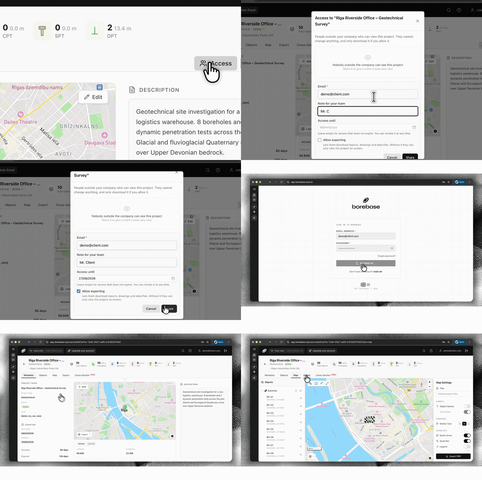
  • New

    Share projects securely with Magic Links

    Give a client, contractor or partner access to one project without adding them to your company workspace. Set an expiry date and decide whether they can export data or keep access view-only.

    Configure secure external project access with a Magic Link
    Set access, expiry and export permissions, then share the same live project.
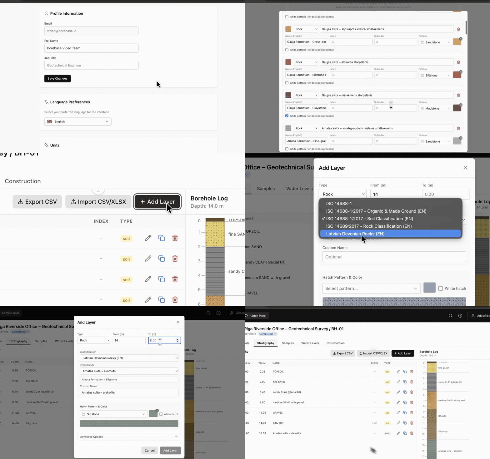
  • New

    Save stratigraphy as a reusable preset

    Build your own stratigraphy preset in Settings and reuse it whenever you enter borehole data. Keep classifications, layer details, hatches and colours consistent across projects.

    Create and reuse a stratigraphy preset while logging a borehole
    Create it once in Settings. Reuse it while logging a borehole.
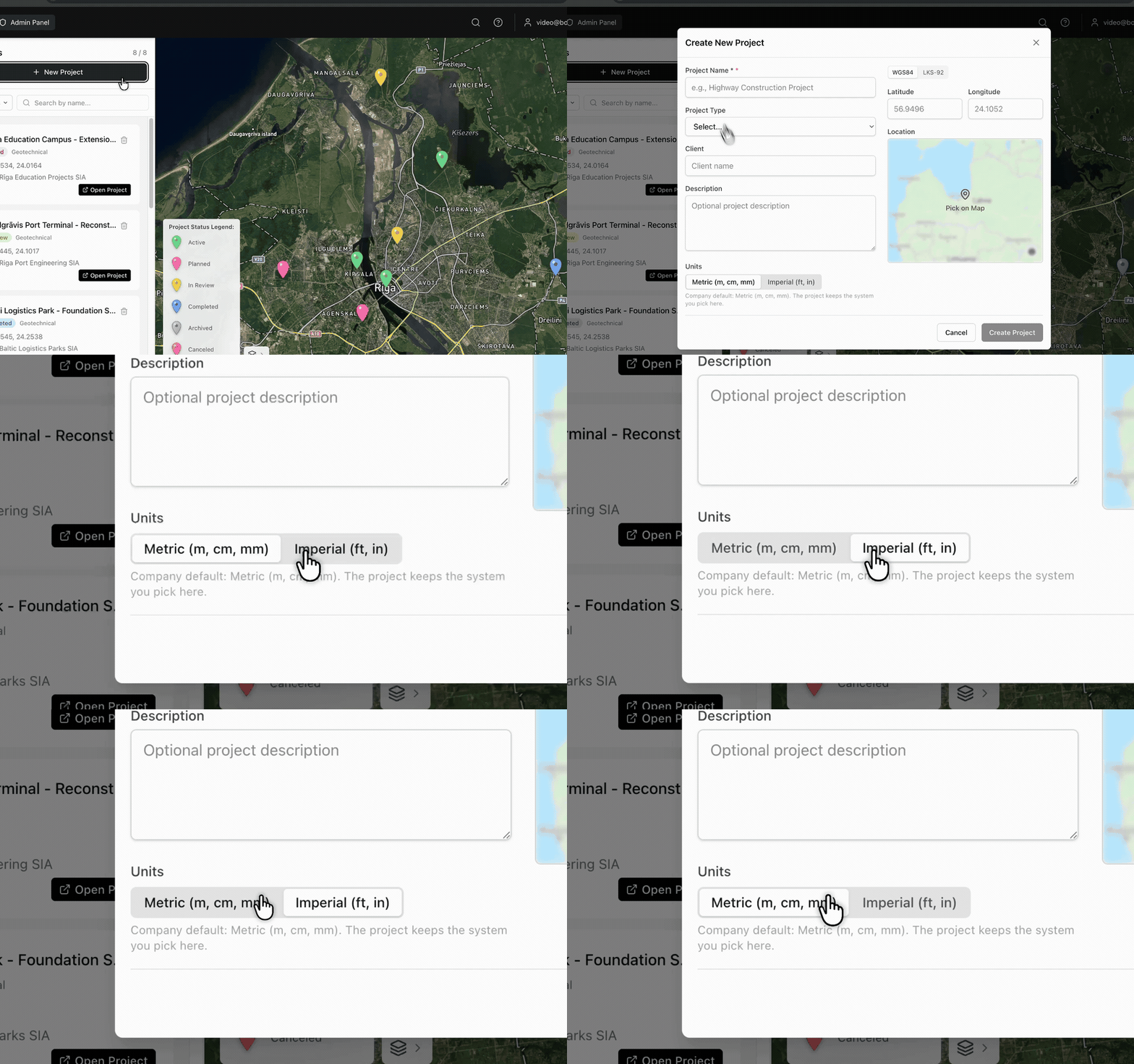
  • New

    Choose metric or imperial units by project

    Select Metric (m, cm, mm) or Imperial (ft, in) when you create a project. Borebase keeps the selected unit system with that project.

    Choose metric or imperial units while creating a project
    The unit system is selected at project creation and stays with the project.
v1.3.0

Faster maps, lighter exports

  • Improved

    Project maps load faster on repeat visits.

  • Improved

    Large PDF reports build noticeably faster on projects with many boreholes.

  • Fixed

    Cross-sections with a single object no longer show an empty axis.

Cookie Consent

We use essential cookies for authentication and security. We do not use analytics or advertising cookies; if that ever changes, we will ask for your consent first. Learn more